North East England
Appearance

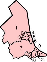
North-East Englandis one of the nine officialregions of Englandand includes the combined area ofNorthumberland,County Durham,Tyne and Wearand a small part ofNorth Yorkshire.
The highest point in the region isThe Cheviot,in Northumberland, at 815m and the largest city isNewcastle.Sunderlandis the second-largest.
The region is known for its urban centres and for its natural beauty:Northumberland National Park,the region's coastline, its section of thePenninesandWeardale.It also has great historic importance. There are twoWorld Heritage Sites:Durham CathedralandHadrian's Wall.
Local government[change|change source]
The officialregionconsists of the following subdivisions:
| Map | Ceremonial county | County /unitary | Districts |
|---|---|---|---|
 |
1.Northumberland† | a.)Blyth Valley,b.)Wansbeck,c.)Castle Morpeth,d.)Tynedale,e.)Alnwick,f.)Berwick-upon-Tweed | |
| Tyne and Wear* | 2.Newcastle upon Tyne,3.Gateshead,4.North Tyneside,5.South Tyneside,6.Sunderland | ||
| Durham | 7. Durham † | a.)Durham (city),b.)Easington,c.)Sedgefield,d.)Teesdale,e.)Wear Valley,f.)Derwentside,g.)Chester-le-Street | |
| 8.DarlingtonU.A. | |||
| 9.HartlepoolU.A. | |||
| 10.Stockton-on-TeesU.A. (North of River Tees) | |||
| North Yorkshire (part only) |
10.Stockton-on-TeesU.A. (South of River Tees) | ||
| 11.Redcar and ClevelandU.A. | |||
| 12.MiddlesbroughU.A. | |||
Key:shire county= † |metropolitan county= *
Other websites[change|change source]
- North East EnglandArchived2019-12-02 at theWayback Machine
- The North East HUBArchived2014-03-10 at theWayback Machine
- North East Regional AssemblyArchived2008-03-20 at theWayback Machine
- The North East Biodiversity ForumArchived2021-12-18 at theWayback Machine
- Future Races in North East England
