Flesberg
Appearance
Flesberg kommune | |
|---|---|
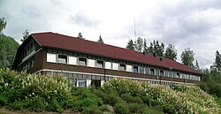
 Flesberg Council Offices at Lampeland | |
 Flesberg within Buskerud | |
| Coordinates: 59°50′52″N 9°28′56″E / 59.84778°N 9.48222°E | |
| Country | Norway |
| County | Buskerud |
| District | Numedal |
| Administrative centre | Lampeland |
| Government | |
| • Mayor (2003) | Egil Langgård (Ap) |
| Area | |
| • Total | 562 km2 (217 sq mi) |
| • Land | 538 km2 (208 sq mi) |
| • Rank | 190 in Norway |
| Population (2004) | |
| • Total | 2,512 |
| • Rank | 302 in Norway |
| • Density | 5/km2 (10/sq mi) |
| • Change (10 years) | 0.2% |
| Demonym | Flesberging[1] |
| Time zone | UTC+01:00 (CET) |
| • Summer (DST) | UTC+02:00 (CEST) |
| ISO 3166 code | NO-3334 |
| Official language form | Bokmål[2] |
| Website | www |
Flesberg is a municipality in Buskerud county, Norway. In 2023, 2,737 people lived there.
Related pages
[change | change source]References
[change | change source]- ↑ "Navn på steder og personer: Innbyggjarnamn" (in Norwegian). Språkrådet.
- ↑ "Forskrift om målvedtak i kommunar og fylkeskommunar" (in Norwegian). Lovdata.no.
Other websites
[change | change source]Wikimedia Commons has media related to Flesberg.


