Luxor
Appearance
Luxor
الأقصر ⲡⲁⲡⲉ ⲡϣⲟⲙⲧ ⲛ̀ⲕⲁⲥⲧⲣⲟⲛ | |
|---|---|
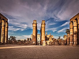
From top, left to right: Luxor Temple,Ramses II,Abu Haggag Mosque,Crocodile Island Resort,feluccason theNile | |
| Nickname: City of Palaces | |
| Coordinates:25°41′N32°39′E/ 25.683°N 32.650°E | |
| Country | |
| Governorate | Luxor |
| Area [source?] | |
| • Total | 416 km2(161 sq mi) |
| Elevation | 76 m (249 ft) |
| Population (2017) | |
| • Total | 506,588 |
| •Demonym | Luxorian |
| Time zone | UTC+02:00(EET) |
| Area code | (+20) 95 |
| Website | www |
| Official name | Ancient Thebes with its Necropolis |
| Type | Cultural |
| Criteria | i, iii, vi |
| Designated | 1979 (3rdsession) |
| Reference no. | 87 |
| Region | Egyptian Governorates,Northern Africa,African Union |
Luxor(Arabic:الأقصر) is a city inUpper Egypt.In 2012, about 506,588 people lived there.[1]To tourists, it is mostly known because ofKarnak,as well as other tourist sites nearby.
Because theAncient Egyptiancity ofThebesis located in Luxor,[2]the city has been called the "world's greatest open-air museum." On the other side of theNilelies theValley of the KingsandValley of the Queens.
References
[change|change source]- ↑"World Gazetteer - Egypt: largest cities and towns and statistics of their population".Archived fromthe originalon 10 December 2012.Retrieved25 November2016.(retrieved 2010-7-27)
- ↑"Luxor, Egypt".Archived fromthe originalon 2013-04-19.Retrieved2016-11-25.
Other websites
[change|change source]- Theban Mapping Project:website devoted to the Valley of the Kings and other sites in the Theban Necropolis
- Luxor World Heritage Site in panographiesArchived2012-12-09 atArchive.today- 360 degree interactive imaging
- GCatholic Copic epachy
- Kamil, Jill (November 2008)."The Development Plan for Luxor".Al-Ahram Weekly,Issue No. 921.Archived fromthe originalon 2009-08-06.Retrieved2016-11-25.
- Luxor Temple picture galleryArchived2010-08-25 at theWayback Machineat Remains.se


