Arunachal Pradesh
Appearance
| Arunachal Pradesh | |
| —state— | |
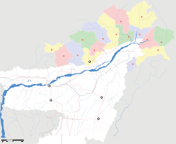
Location of Arunachal Pradesh inIndia
| |
| Coordinates | 27°04′N93°22′E/ 27.06°N 93.37°ECoordinates:27°04′N93°22′E/ 27.06°N 93.37°E |
| Country | India |
| District(s) | 16 |
| Dídásílẹ̀ | 20 February 1987 |
| Capital | Itanagar |
| Largest city | Itanagar |
| Governor | Joginder Jaswant Singh(2008-) |
| Chief Minister | Dorjee Khandu(2007-) |
| Legislature(seats) | Unicameral (60) |
| Population |
1,091,120(26th) •13/km2(34/sq mi) |
| Official languages | Hindi,Deori,Assamese,English,and many local languages. |
|---|---|
| Time zone | IST(UTC+5:30) |
| Area | 83,743 square kilometres (32,333 sq mi)(14th) |
| ISO 3166-2 | IN-AR |
| Website | arunachalpradesh.nic.in |
| Seal of Arunachal Pradesh | |
Arunachal Pradeshjẹ́ ìkan nínú àwọnìpínlẹ̀méjìdínlọ́gbọ̀n ní orílẹ̀-èdèIndia.[1]
Àwọn ìtọ́kasí[àtúnṣe|àtúnṣe àmìọ̀rọ̀]
- ↑"Apang rules out Chakma compromise".Calcutta, India: Telegraphindia.com. 12 August 2003.http://www.telegraphindia.com/1030812/asp/northeast/story_2255514.asp.Retrieved 6 October 2010.


